For those of you flying in there are airports in Knoxville (the closest) and Tri-Cities, Tennessee (A little over an hour away) and I believe there's an airport in Asheville, North Carolina (also probably a little over an hour away). There's a small airport in Pigeon Forge but I'm not sure if it's private or if anyone can fly into there. Flying into Charlotte is also an option (about 3.5 hours driving).
There are many hotels and cabins in the area but it is a busy time of year there so we recommend not waiting too long to book something. The Wears Valley area in Sevierville is a good one to check out since it is not that far from where the wedding will take place and it also is easy to get to Pigeon Forge (where Saturdays pizza party is being held). There are many hotel options in Pigeon Forge and Gatlinburg and the town of Townsend is not far away and provides a more relaxed atmosphere than Gatlinburg or Pigeon Forge. Townsend is where Cades Cove is located and provides easy access to the Great Smoky Mountains national Park (GSMNP). If anyone needs suggestions or names of places, please feel free to contact us and we will be glad to help.
For those driving, I found this article that has a list of alternative driving routes that some might find interesting (sorry links might not work since I just copy and pasted this)...
Planning on visiting Pigeon Forge? Most of us probably know the way by heart, taking Exit 407 from I-40 and following the Parkway to the destination. This is by far the most popular route to Pigeon Forge, with more than 50,000 people driving through the Parkway every single day.
Sometimes, though, taking the beaten path may mean sitting in traffic with rush hour or in line with the thousands of other visitors coming to Pigeon Forge. But, we’re here to help you skip the wait and get to having fun faster with these 7 alternative routes. The routes are split into four categories, depending on which direction you’re coming from.
Atlanta, GA to Pigeon Forge, TN (South)
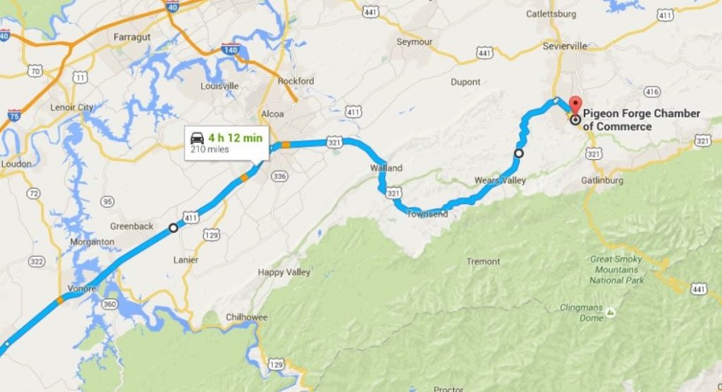
1. Hwy. 441 to Hwy. 321
Time: 4 hours, 17 minutes
Benefits: Bypass traffic in Knoxville and Exit 407 on I-40, beautiful rural views, historical towns, travel alongside the Great Smoky Mountain National Park
Google Map link: https://goo.gl/maps/apPVyH6EMQK2
This route is an excellent choice for northbound travelers that dislike the interstate or those that crave rural views. Taking this route means you’ll be able to bypass Knoxville traffic while experiencing historical towns like Townsend and Wears Valley.
Take I-75 North from Atlanta to Exit 293; follow the fork to the right to enter onto 441. From there you’ll be travelling along beautiful Highway 441 north for 25.1 miles, experiencing peaceful rural views along the way. Folks that prefer to travel by I-75 North to Tennessee can just take Exit 27 at Lenoir City to directly enter Highway 321.
 A view of Wears Valley from a GSMNP trail. Photo by Melinda Fawver.
You’ll cross the Little Tennessee River before you enter into Maryville. This is a great place to check out if you’re looking for a pit stop, with historic Maryville College, a beautiful downtown shopping area, as well as the Foothills Mall. . Eventually, you’ll come to a junction after passing Maryville High School where you’ll turn right onto Highway 321, W. Lamar Alexander Parkway.
Continue on Highway 321, which will take you through the beautiful towns of Townsend and Wears Valley. Townsend is a gateway to the Great Smoky Mountains National Park as well as Cades Cove. There’s also plenty of shops and cool restaurants to check out in Townsend. Another great stop along this route is Wears Valley, a small town with a big personality and lots of history. You’ll find lots of craft shops and one-of-a-kind stores in this town. If you’re looking for things to do in Maryville, Townsend, or anywhere in Blount County, be sure to visit the Blount County Chamber of Commerce‘s website for cool ideas and tips. Also, visit the Wears Valley Chamber of Commerce’s website for some tips on things to do in Wears Valley.
If you follow Highway 321 through Townsend and Wears Valley, you’ll eventually find yourself on the Parkway, right in the heart of Pigeon Forge.
 From Google Maps
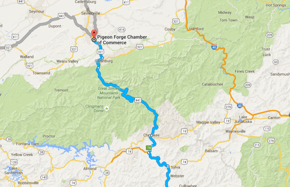
2. Hwy. 23 North Through Cherokee, NC
Time: 3 hours, 55 minutes
Benefits: Drive through a national forest and a national park on your way to Pigeon Forge, visit several small historic towns, experience the cultural center that is Cherokee, NC
Google Maps Link: https://goo.gl/maps/ZJHCFWCSjJ62
 Cherokee, NC is rife with beautiful mountain views, much like Pigeon Forge and Gatlinburg.
From Atlanta take I-85 North towards Greenville, SC until you come to Exit 113. Take the exit onto I-985 North and follow the bypass north past Lake Lanier. Eventually the bypass turns into Highway 23 North. Follow the highway through beautiful rural country. After travelling on Highway 23 North for 29 miles, you’ll come to the point where Highway 441 feeds into Highway 23; keep left to continue travelling north through Chattahoochee National Forest.
After a beautiful 28 mile stretch through the National Forest you’ll continue on Highway 23 until you come to an intersection. At this point, you’ll take a right to continue onto Highway 23 and continue north until Highway 23 ends. From there you’ll take to enter Highway 74, which is where you’ll continue until you take Exit 74 to US-441. Continuing on US-441 for around five miles, you’ll find yourself in Cherokee, NC.
Cherokee is an amazing town to stop and explore. You can check out the Musuem of the Cherokee Indian to learn more about the native people that still call Cherokee home, or visit one of the many shops offering authentic and interesting wares. Cherokee is also home to Harrah’s Cherokee Casino, one of the only casinos of the area.
Once you pass through Cherokee, you’ll find yourself in the Great Smoky Mountain National Park by way of US-441. This is one of the most beautiful sections of the drive. Be sure to take your time to enjoy the river running alongside the road and the prepossessing mountain views. Be careful, though, as you transverse this path, as the road has several sharp curves that could take the unsuspecting driver by surprise.
Once you pass the Sugarlands Riding Stables you should come to the Gatlinburg bypass on your left. Take this exit and you’ll go through another amazingly scenic drive, complete with mountain overlooks with a bird’s eye view of Gatlinburg. The bypass will take you around Gatlinburg traffic and drop you off in the wooded area connecting Pigeon Forge and Gatlinburg, know to locals as The Spur, which will take you directly to Pigeon Forge, TN.
 From Google Maps
Asheville, NC to Pigeon Forge, TN (East)
Folks travelling to Pigeon Forge from the East typically take I-40 West to Exit 407, but there’s a much more scenic way to reach Pigeon Forge while simultaneously getting the chance to see amazing mountain and rural views.
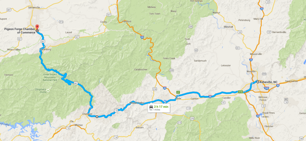
3. US-19 South Through Cherokee, NC
Time: 2 hours, 17 minutes
Benefits: Beautiful rural views, drive through historic Cherokee, NC, creeks that run alongside the road, final stretch through the national park
Google Maps Link: https://goo.gl/maps/6i91mAUsnqF2
Travelers on this route will take I-40 West Towards Knoxville and follow the interstate to Exit 27 in Clyde, NC and enter into Highway 74. You’ll travel on Highway 74 for a little over 2 miles past Haywood Regional Medical Center and Tuscola High School before taking Exit 103 onto Highway 19 / Dellwood Rd. Once you enter Highway 19 you’ll see beautiful Lake Junaluska to your right.
You’ll travel along Highway 19 for several miles, eventually coming to Cherokee, NC. Once you cross the bridge that transverses the Oconaluftee River, you’ll take your first right to enter Highway 441 / Tsali Blvd.
Once you enter onto Highway 441, you’ll take the same route discussed in route number 2 on this list, travelling through the Great Smoky Mountains National Park and taking the Gatlinburg bypass to arrive in Pigeon Forge.
 From Google Maps
Nashville, TN to Pigeon Forge, TN (West)
Visitors coming to Pigeon Forge from the west usually have to contend with Knoxville traffic before taking the final stretch to Exit 407. These two routes will help you bypass Knoxville and offers and easy-going drive.
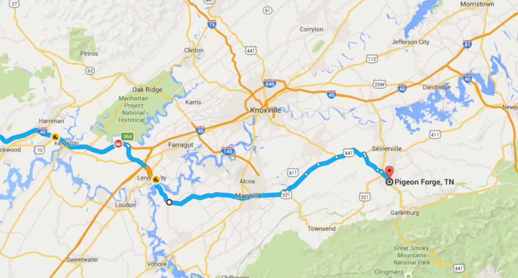
4 & 5. Hwy. 321 to Pigeon Forge
Time: 3 hours, 30 minutes
Benefits: Skip Knoxville traffic, drive through historic towns, enjoy beautiful mountain scenery
Google Maps link: https://goo.gl/maps/957KV9nnXM12
Travelling on I-40 West, take Exit 364 in Lenior City. From there, you’ll enter Highway 321, which will take you through Maryville.
Once you’ve driven through Maryville, you’ll have a decision between two routes of roughly equal distance. On the first route, you can continue on Highway 321 through Townsend and Wears Valley, arriving in the heart of Pigeon Forge. This route is relatively straightforward, and will take you down a winding path that features breathtaking mountain views.
Alternatively, you can take a left on Ellejoy Rd. from Highway 321 roughly 4.5 miles outside of Maryville. Ellejoy Rd. eventually feeds into Chapman Highway / US Highway 441. Following 441 will take you through a beautiful rural setting. After about 5 miles on Chapman Highway, you’ll take a right onto River Divide Rd., the latter half of which runs alongside the West Prong Little Pigeon River. As River Divide Rd. ends, you’ll take a left across a bridge to Henderson Rd., and then your first right onto Henderson Chapel Rd., which will drop you on the Parkway right next to Music Road Resort Hotel.
 From Google Maps
Cincinnati, OH to Pigeon Forge, TN (North)
6. I-75 to Chapman Hwy. and Pigeon Forge
Time: 4 hours, 25 minutes
Benefits: Shorter drive than via I-40 east, travel through Seymour, scenic final stretch
Google Map link: https://goo.gl/maps/QLKErrGeCMm
Many people travelling to Pigeon Forge from the north take I-75 south to I-40 east to Exit 407, but travelers can easily take advantage of this alternate route to get to Pigeon Forge quicker and easier.
Driving along I-75 south, you’ll follow the interstate to US-441 / Henley St. once you pass through Knoxville, rather than entering I-40. From there you’ll follow US-441 / Chapman Highway through Seymour along the same path described in number 5 on the list.
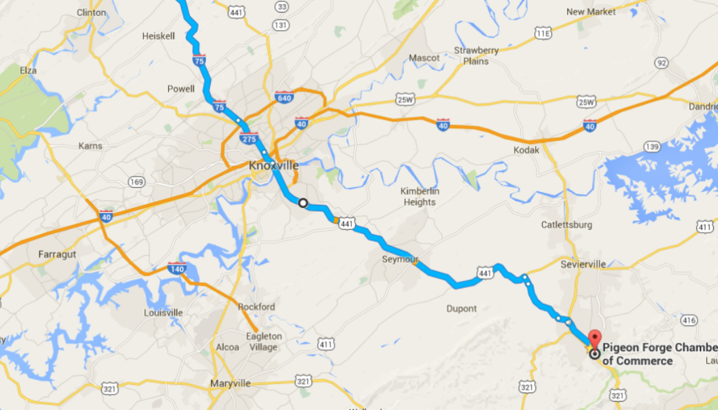 From Google Maps
7. Hwy. 25 E Through Morristown to Pigeon Forge
Time: 5 hours, 21 minutes
Benefits: A beautiful drive down historic Highway 25 E, cool towns along the way such as Morristown, lake and reservoir views
Google Maps link: https://goo.gl/maps/kPV5rbtvnrx
Rather than following I-75 to Knoxville, visitors seeking a more scenic drive south can take Highway 25 E south. Highway 25 E is a beautiful drive with a long history as Thunder Road, the moonshine highway. Additionally, travelers will pass through Morristown, an awesome pit-stop with plenty of options for shopping, sight-seeing, and dining.
Travelling down I-75 South take Exit 29 in Corbin, KY to enter Highway 25 E. This route will take you south through Kentucky and into northeast Tennessee. You’ll cross over the breathtaking Cherokee Reservoir before driving through Morristown, and will then cross over Douglas Lake.
When you reach the end of Highway 25 E in Newport, TN, take a right onto Highway 25 W and then a left onto Highway 441 shortly after passing under the interstate. Following US-441 will take you the back way to Sevierville.
Once you enter Sevierville, take a left onto Veterans Blvd. (you’ll know to turn when you see the Taco Bell). Veterans has much less traffic than the Parkway while running parallel to it. travelling the entirety of the length of Veterans Blvd. you’ll pass right by Dollywood and be dropped off on the parkway in the heart of Pigeon Forge.
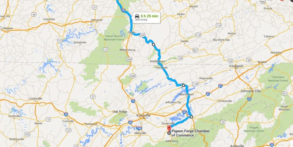 From Google Maps
And there you have it! 7 scenic alternative routes to Pigeon Forge that help you skip traffic and see beautiful sights! |